


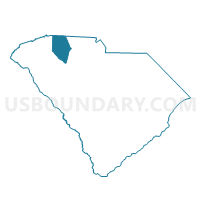
Landrum United Methodist Voting District, Spartanburg County, South Carolina
About
Outline

Summary
| Unique Area Identifier | 666694 |
| Name | Landrum United Methodist Voting District |
| County | Spartanburg County |
| State | South Carolina |
| Area (square miles) | 20.18 |
| Land Area (square miles) | 20.13 |
| Water Area (square miles) | 0.04 |
| % of Land Area | 99.78 |
| % of Water Area | 0.22 |
| Latitude of the Internal Point | 35.16446380 |
| Longtitude of the Internal Point | -82.17136350 |
Maps


Graphs
Select a template below for downloading or customizing gragh for Landrum United Methodist Voting District, Spartanburg County, South Carolina


Neighbors
Neighoring Voting District (by Name) Neighboring Voting District on the Map
- Voting District CL08, Polk County, NC
- Voting District GC09, Polk County, NC
- Gowensville Voting District, Greenville County, SC
- Landrum High School Voting District, Spartanburg County, SC
- Swofford Career Center Voting District, Spartanburg County, SC
- Voting District TR123, Polk County, NC
Top 10 Neighboring County Subdivision (by Population) Neighboring County Subdivision on the Map
- Highland CCD, Greenville County, SC (14,703)
- Landrum CCD, Spartanburg County, SC (7,253)
- Columbus township, Polk County, NC (6,474)
- Fingerville CCD, Spartanburg County, SC (6,172)
- Tryon township, Polk County, NC (3,747)
- Green Creek township, Polk County, NC (3,607)
Top 10 Neighboring Place (by Population) Neighboring Place on the Map
Top 10 Neighboring Unified School District (by Population) Neighboring Unified School District on the Map
Top 10 Neighboring State Legislative District Lower Chamber (by Population) Neighboring State Legislative District Lower Chamber on the Map
- State House District 113, NC (75,113)
- State House District 38, SC (37,612)
- State House District 17, SC (37,353)
Top 10 Neighboring State Legislative District Upper Chamber (by Population) Neighboring State Legislative District Upper Chamber on the Map
- State Senate District 48, NC (193,127)
- State Senate District 5, SC (115,205)
- State Senate District 12, SC (106,880)
- State Senate District 11, SC (101,438)
Top 10 Neighboring 111th Congressional District (by Population) Neighboring 111th Congressional District on the Map
Top 10 Neighboring Census Tract (by Population) Neighboring Census Tract on the Map
- Census Tract 224.01, Spartanburg County, SC (6,172)
- Census Tract 225, Spartanburg County, SC (3,950)
- Census Tract 24.04, Greenville County, SC (3,444)
- Census Tract 226, Spartanburg County, SC (3,303)
- Census Tract 9201.03, Polk County, NC (3,197)
- Census Tract 9203.04, Polk County, NC (2,874)